
Hiking Ergeshan (二格山) is something that you’ll want to add to your things to do on your next visit to Taiwan. While not as popular as hikes like Elephant Mountain or Jiantanshan, the views are just as spectacular.
Hiking in Taiwan is a remarkable experience and Taiwan’s Xiao Bai Yue (小百岳) is a great place to start. Taiwan’s Xiao Bai Yue is a perfect list of 100 suburban mountain peaks suitable for hikers of all skill levels.
The Xiao Bai Yue is 100 mountain climbs oriented towards sub-urban destinations and routes suitable for novice hikers. These include beginner routes like Dawulun Mountain, novice routes like Dongyanshan National Forest and some that are more challenging, like Jialishan.
About Ergeshan (二格山)
Ergeshan (二格山) is listed at #017 of the Xiao Bai Yue (小百岳). Located in Wenshan District (文山區) in Taipei City (台北市), Ergeshan is a fantastic urban mountain hike that offers nearly 360 degrees views of Taipei City and the surrounding mountain areas.

Hiking Ergeshan (二格山)
We started our hike at the trailhead near Caonan (草湳) bus stop. You will be dropped off at a road junction. Walk to the right where the road widens significantly and you’ll continue on this for 100m or so. When the road ends, the wide paved path begins. This section quickly turns to gravel/compact soil and has a small stream along the right side.
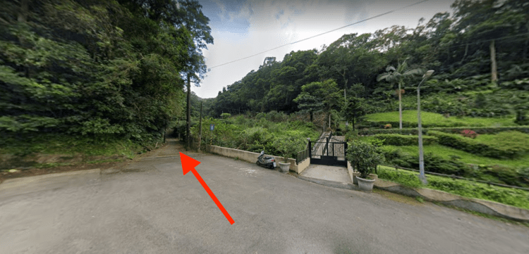
The trail turns into a double track dirt road that is a smooth and slow climb in a dense forest. As the route progresses up the mountain, the trail becomes slightly more rocky and steeper. You’ll pass by some forest land temples and some old (military?) buildings along this first section. Around the 1.7-2km mark of this hike the trail transitions into single track, compact soil and becomes a little bit more rugged.

Well Maintained Trails
The hiking community in Taiwan has installed some ropes to assist hikers on some of the steeper sections. The trail is a mix of shaded (70%) and unshaded (30%). It’s a dense, humid forest with lots of song birds if you hike early morning. This trail continues to weave its way through the mountain and ascends to towards the peak of Ergeshan.

At the peak hikers are rewarded with absolutely stunning views. Look north across Taipei and south over the lush green surrounding mountains and the blues of Fei-ts’ui Reservoir 翡翠水庫. Located adjacent to the large wooden pavilion you will find a small cornerstone representing the peak. It’s worth spending some time relaxing up there. Bring a lunch, bring a book and enjoy the fresh air.

Coming down from the peak, this route takes hikers along some steep stone steps. While they are deep and well kept, they can get slippery. Turn left when you arrive at the paved single lane road. Continue on this road until it ends and transitions into a stone and compact soil trail. From here, follow this trail for about 1km before it pops out onto a roadway. Carry on and turn left and continue on this until you return to your car or arrive at the Caonan (草湳) bus stop. You’ve just finished your journey of Hiking Ergeshan (二格山).

What to Bring
When hiking Ergeshan (二格山) consider your capabilities before heading out. We hope this helps provide insight into the level of difficulty. When it comes to the kinds of equipment or resources one should bring when hiking this trail in Taiwan, we’ve provided a list below:
- Gloves – As there are some ropes along portions of the trail, you may wish to bring gloves. Not completely necessary though.
- Water – About 1 to 1.5L of fresh drinking water
- Food – There are no services along this trail.
- Washrooms – Available at temple near bus stop. No washrooms on trail.
- Sunscreen – The trail is mostly shaded, with about 30% unshaded. The peak is open, so if you’re spending much time up there you may wish to wear a hat or have some sunscreen on.
- Camera/Phone – Reception is near perfect on this trail!
How to Get to Ergeshan (二格山)
Driving to Ergeshan (二格山): If you are driving, you can set this as your location – HERE. This will take you to a small area for parking with the trailhead found at the end of the road. Ergeshan is approximately 30 minutes from Taipei Main Station by car.
Taking public transportation to Ergeshan (二格山): From Muzha MRT Station, you can get to the trailhead for Ergeshan in just under 1 hour. From here, exit the Muzha MRT Station, walk south along Muzha Road Section 4 to Wanfang Road Intersection to catch the S10 Caonan Bus. From here, take this bus for 26 stops until the Caonan stop. The trailhead is 10 minutes by foot from there. Here is the Google Route.
Map & GPX File

(return)

Steep stone steps, wooden steps & compact soil


Time Required: 3 hours
