
TLDR: Regardless of how you feel about the climb up while hiking Shizitoushan, you’ll love the views of the surrounding mountains and villages.
Hiking in Taiwan is a remarkable experience and Taiwan’s Xiao Bai Yue (小百岳) is a great place to start. Taiwan’s Xiao Bai Yue is a perfect list of 100 suburban mountain peaks suitable for hikers of all skill levels.
The Xiao Bai Yue is 100 mountain climbs oriented towards sub-urban destinations and routes suitable for novice hikers. These include beginner routes like Dawulun Mountain, novice routes like Dongyanshan National Forest and some that are more challenging, like Jialishan.
About Shizitoushan (獅仔頭山)
Shizitoushan (獅仔頭山) is listed at #020 of the Xiao Bai Yue (小百岳). Located in Xindian District (新店區) in New Taipei City (新北市), Shizitoushan is a fantastic urban mountain easily accessible from downtown Taipei. Shizaitou Mountain is located in the mountainous area of Xindian District south of Taiwan’s Capital, Taipei. This mountain is named after the fact that the mountain is believed to look like a crouching lion. It is the highest peak in Xindian District at 857 meters above sea level.

There are also a number of historical sites along Shizaitoushan Trail including ancient wells, trenches and others ruins as well as Fangfan monuments, which can be traced back to the Qing Dynasty and the Japanese occupation period. Much of these sites have connections with aboriginal, Han Chinese and Japanese cultures. If you want to enjoy some native flowers, aim to hike this trail between March and May when the Rhododendron chinensis are in bloom. This trail is rated as moderate simply because it does have some steeper sections and requires some moderately technical sections. Suitable for families with some hiking experiences and comfort on a trail with steep sections.
Hiking Shizitoushan (獅仔頭山)
Hiking to the peak of Shizitoushan and back takes about 1.5-3 hours depending on how many pictures you take and how long you take to explore the local area. The trailhead begins directly off the roadway and features wooden stairs that last for about 750 meters (15 minutes). There is also a wooden boardwalk which is nice when the weather is wet. After this first section, you will arrive at Shizitou Guanshiping (觀獅坪) which is a flat open area that overlooks the mountain peak.

After this first 15-20 minutes, the real journey begins while hiking Shizitoushan. The trail increasingly gets more natural with more compact soil surface mixed with roots and rocks as you ascend up. There are also some steeper sections as well but nothing too difficult.

From the clearing, hikers essentially ‘enter’ the Lion Head Trail, as you begin a series of step stairs up. There are rope bannisters and the trail is well-maintained, but as you approach a towering rock face you’ll see one of the features this trail is well known for. This famous feature of Lion’s Head Mountain is the almost vertical climb up a wooden ladder to the sky. Some people love it, some people hate it.

Hiking Shizitoushan is Worth the Effort!
Regardless of how you feel about the climb up, you’ll love the views, which, on a clear day, offer spectacular views of the surrounding mountains and villages. Hiking in Taiwan certainly never disappoints and this combination of a fun little climb and views as the reward is no different! There are two other similar wooden ladders, but each of these are much shorter.

The trail is a bit narrow here and steeper that requires a bit of scrambling up the mountain. Be careful. There are ropes to assist so consider bringing gloves. Once you’ve ascended the short steeper section, the trail flattens out a bit more. Keep an eye out for the hundred year old camphor tree as you continue along.

There are lots of great to enjoy the views. The first peak has a small cleaning before you continue along a camphor-forested ridgeline. The next 100m or so while hiking Shizitoushan features the Fangfan Monument, which was erected during the Japanese Occupation during conflicts with the local indigenous people, the Atayal tribe.

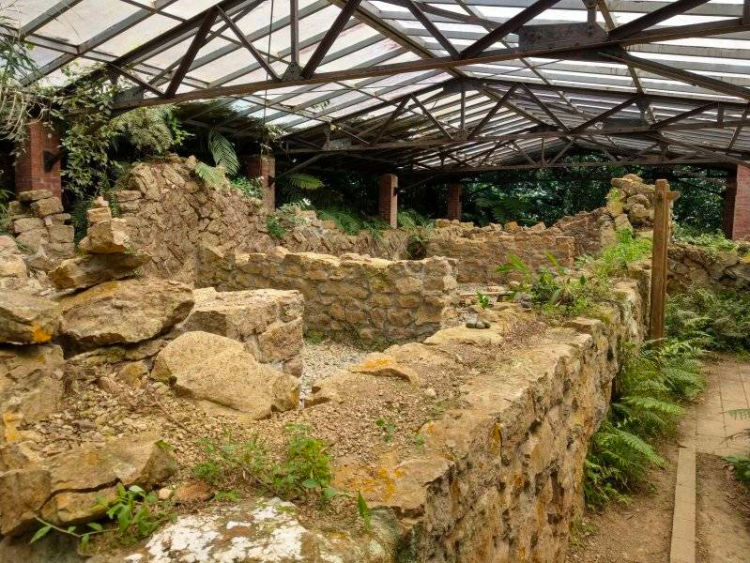
Ancient Ruins of the Japanese Era
Continue along and descend down into a valley along a natural trail to the Shiliao ruins with a modern roofing to protect the ancient ruins. These facilities were likely used as a outpost during Camphor tree extraction during Japanese occupation. Continue along a natural path for a short distance. Keep an eye out for a fork in the Shizitoushan Trail, with a old trail sign indicating the triangulation point off to the right. At the second fork in the trail, take the right trail again and you’ll arrive at the triangulation point. While there are nice spots to view the surrounding countryside along this trail, the peak is forested and offers no such views.
Go back to the first fork in the trail and take the left path if you wish to get down to see the “Lion’s Mouth”. The steep descent down a rocky and rooty path take hikers to see small cave opening. Legend has it that a resistance militia used the cave as a sentry post between 1896-1898 when the Japanese first invaded Taiwan. There is a smaller cave located close by, as well as a really beautiful Guanyin ‘Cave’ surrounded by a massive rock cliff. It’s not so much a cave as it is a cliff with nice views of the valley.

The trail then connects to the last section of the looped route, which becomes much more primitive and rugged. There are some roped sections and some areas that are much steeper, including a 10ft rock face that requires climbing with ropes. There is also a simple public toilet available for use. This leg circles back and pops you out at the left side of the “Lion’s Head” about 15 minutes from the trailhead.

What to Bring While Hiking Shizitoushan
When hiking in Taiwan consider your capabilities before heading out. We hope this helps provide insight into the level of difficulty. When it comes to the kinds of equipment or resources one should bring when hiking this trail in Taiwan, we’ve provided a list below:
- Gloves – Gloves are strongly advised on this trail.
- Water – About 1.5-2L of fresh drinking water
- Food – There are no services along this trail or at the trail head. Bring everything you’ll need for the day.
- Washrooms – One public toilet is available on the second half of the trail.
- Sunscreen – The trail is mostly unshaded, with about 30% shaded. The peak is open, so if you’re spending much time up there you may wish to wear a hat or have some sunscreen on.
- Camera/Phone – Reception is near perfect on this trail!
How to Get to Shizitoushan (獅仔頭山)
Driving to Shizitoushan (獅仔頭山): If you are driving, you can set this as your location – HERE. Note that there are only two parking locations, but parking on the side of this road is permitednd parking can be difficult at times. Come early if you wish to beat the crowds.
Taking public transportation to Shizitoushan (獅仔頭山): From Taipei Main Station, take the train to Yingge Station. When exiting the Yingge Train Station, go out the south side towards Dingying Village Office to catch the 5001 Bus for 8 stops to the Fishing Net Factory. From here you will hve to walk an additional 2.1km to trail head. Here is the Google Route.
Map & GPX File

(return)

Compact soil, wooden steps


Time Required: 2.5-3 hours
